After months of planning for the three peaks challenge, it was cancelled. I had already taken money for the J.A.C.K charity and donated it, so I felt I had to do something ,plus I was really looking forward to it anyway.
So I decided that my mate Steve and I would take on the highest peak in Wales and England (Snowdon and Scafell Pike) over two days as I was doing all the driving between peaks.
So on Sunday the 27th June 2010 we left Romford at 6am for a 4 and a half hour drive to the Base of Snowdon.
SNOWDON (Yr Wyddfa) 27th June 2010
We decided to take the Llanberis Path up Snowdon. After parking in
Llanberis we made our way pass the
Snowdon Mountain railway that takes the lazy people up Snowdon and made our way to the path.This is my first mountain climb and I really wasn't sure what to expect or how difficult I would find it! I needn't worried, it was fantastic even if I did walk like I had shat myself at the end of the day, my legs did ache a little lol.
Distance - 5 miles (10 miles return) Grade - Moderate Mountain Walk Grid Ref. - SH 581594.
At first, the path winds steeply up the metalled track, with Coed Victoria, a small partly felled conifer plantation, on your left.At the gate, look behind you at the fine view of the
Llanberis Pass,
Llyn Padarn, the Padarn Country Park and the old slate quarry, now the site of a huge underground pumped storage scheme.
The path now climbs gently, parallel with the railway track on the right. Eventually you come to a gate and a stile where the railway crosses the path over a bridge. Up the valley you can see
Moel Hebog in the distance over Bwlch Cwmbrwynog, the pass between
Clogwyn Du’r Arddu and
Moel Cynghorion. Further on you will see a huge rock, Maen Du’r Arddu, in the valley to the right of Clogwyn Du’r Arddu. Local legend has it that if a person should spend a night under the rock, the morning will find him either a poet or a madman. It is now a short walk to the Half Way House at 1,700ft., where in summer, when the train is running, you can buy refreshments. I stopped here and had some water, chocolate and mints before continuing up.
The climbing now begins in earnest, for the left-hand path is the one you must take. It is known locally as “Allt Moses” (Moses’ Hill). The ground is loose and bouldery and very slippery in wet weather. Good boots are essential from here on. Whilst resting during the steep ascent, look down to your right and you will see the sinister green waters of Llyn Du’r Arddu, where the miners used to wash the copper ore.
Soon you pass under the railway track once more, close to Clogwyn Station, where you are rewarded by a fine view of the Llanberis Pass and the
Glyderau opposite. The cwm below you is Cwm Glas Bach, also known locally as Cwm Hetiau (the Cwm of Hats). In the days of open trains the wind used to blow off travellers’ hats, and if a local person needed a new hat he had only to look about in the cwm to find one!
Today was no different,I took my cap off before the wind took it away!
The path becomes even steeper from now on. The lake you can see over the top of
Clogwyn Du’r Arddu is
Llyn Cwellyn, which supplies
Caernarfon with its water.
The path soon levels out and on your right, you will see the Snowdon Ranger Path. From now on, the path is well defined. Shortly you will be able to see a monolith marker stone, where the Snowdon Ranger Path, that used to be on your right, meets the railway track. A few yards further on, you come to another, larger, monolith at Bwlch Glas, which marks the top of the famous zigzag on the Pyg Track to your left. It is now only about 15 minutes to the top.
Looking down on our path up.
A Happy Me on the
Snowdon summit after a 2 hour 15 minute climb!! 3,560ft 1085 metres!
Steve on the summit in the now misty conditions, no view to be had from the summit!.
We had a hot chocolate in the cafe and bought some gifts and sent a postcard from the Uk's highest postbox.
Now the descent, we got down in 1 hour 30 minutes.
Got to see the second half of England v Germany in the world cup game in a pub down in Llanberis. Only wished I hadn't! The pub was full of Germany supporting Welsh and Engalnd lost 4-1!! and there was me standing there in a England shirt...embarrassing!
We then popped round to
Petes Eats for dinner before attempting to find a bed in
Llanberis YHA but his was full so we got a bed in
Pen-Y-Pass YHA for £20 each for the night.Popped outside to take in the views ofg Snowdon from the hostel, don't look half as big from here!
Not a bad hostel, apart from the Chinese fellas going on all night asking some poor guy questions about the UK. Thought they'd never shut up. Had a ale and some toast , a shower and then was out like a light!
One thing that springs to mind was the weather, people always say it always rain in Wales!! Not when I've been there the weather has always been kind!
SCAFELL PIKE , The Lake District 28th June 2010
The next morning we were up at 7am, had breakfast and were ready for the 4 and a half hour drive to Wasdale in the Lake district to climb
Scafell Pike. at 3,210ft 978 metres using the brown tongue path.We parked up by
Wasdale Inn ready for the climb.
Route 1. Via Brown Tongue. 2½ miles. 2,993 feet of ascent.
.
This is the shortest and easiest way to the summit of Scafell, much used by charity challengers and peak baggers. It is also probably the least interesting way to the top of England's highest peak, but it does have the appeal of a well made path of stone steps as a sure-fire (if unattractive) guide to the summit. Be warned however that the summit area and to a lesser extent the depression at Hollow Stones is still a place which disorientates the unwary in mist, and no-one should attempt to climb Scafell without the necessary navigational skills and equipment to get unlost if this happens.
The track starts at the National Trust car park just beyond the head of the
Wastwater along the lane to Brackenclose. Just beyond the car park a sign points you in the right direction and you head up
Lingmell Gill beside its tumbling water (the prettiest part of the entire route). You begin to emerge from the confines of the ravine at a stile where the path from
Wasdale head comes in from the left.
We dipped our caps in the stream to cool our heads down,worked a treat.
This was weird a dry river bed !!
A little way beyond here it is necessary to cross the stream on stepping stones which can be precarious after rain. On the other side of the stream, the yellow brick road heads steeply and relentlessly upwards below a parallel grassy ridge (the Brown Tongue).
At around 1770ft. you come to a junction. The right fork heads towards the imposing cliffs of Scafell (route 2). The Brown Tongue route takes the left fork and after negotiating the tumble of glacial debris known as 'Hollow Stones', continues at an easier gradient to reach the col between Scafell Pike and Lingmell.We stopped here for a rest and some bananas and water. It is very easy to lose the path here as there are rocks everywhere and the path isn't so distinctive. We watched two girls take the wrong way and ended up having to scramble over rocks to get back to the path.
The summit of Scafell is quite broad and very rocky.
The summit furniture includes the old O.S. 'trig' column and a massive cairn which actually looks more like a ruined castle than a cairn.
The conditions on the summit were atrocious! High winds, rain and cloud cover. However I was very happy to reach the summit after a 2 hour 10 minute climb. I had a short rest and made my way down, no photos on the way down, just wanted to get out of the rain. I was very wet by the botttom . Found out my boots weren't waterproof! Took 1 hour 30 minutes to get off the mountain. The path had became very slippery in the rain.
Quickly changed into dry socks and shoes and off into
Ritsons bar for a drink!
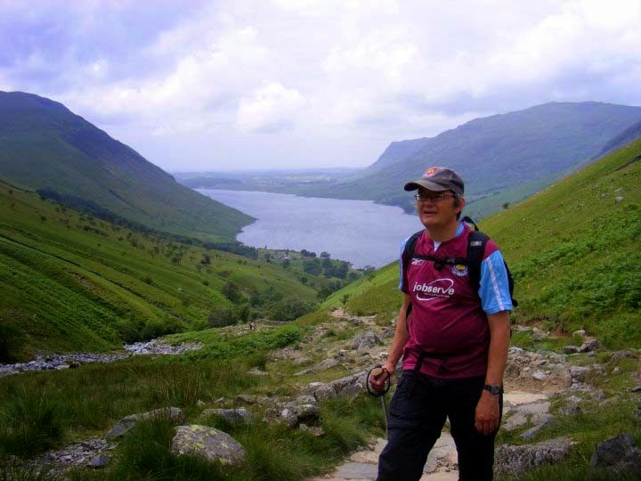
As you can see, this photo was taken before I went up, hence no rain :)
I then made the decision to stay the night rather than drive home as it would be gone midnight by the time I got back and didn't want to drive tired.We got ourselves booked into the
Wastwater YHA for £19 for the night. Got our wet gear into the dry room which most was still wet in the morning. Made some dinner, chatted to some nice fellas from Holland who were motorbiking it around The Lakes
. It was then a cup of tea , a shower and bed.
It rained all night, however the morning was different. whilst waiting to see if we could have a cooked breakfast as there was a power cut. We strolled across the front of the YHA to the Wastwater lake. Words can't describe , but pictures have a go.
The power was back on a full breakfast was had, Bacon,sausage,scrambled eggs,hash brown,baked beans,mushrooms,tomato,toast and jam,croissant and jam,yoghurt and tea and coffee not bad for £4.95 .
We then packed the car up for the 6 hour drive home and said goodbye to the Lakes and the YHA.
Thank you to everyone that sponsored me and thank to Mel and the kids for allowing me the time away to do these amazing climbs.
Ben Nevis is still waiting as this was part of the original 3 peaks....maybe soon.


